Life is a journey
これからここに旅の記事を連載することになりましたのでどうぞよろしく!ってことで僕のことを少し紹介させていただきます。
I’m going to be writing a series of travel articles here. Nice to meet you! So let me tell you a little about myself.
中島力(ナカジマリキ)
「何やってる人なんですか?」と聞かれることが多く、その説明にいつも困るんですが
肩書きとしてはプロスキーヤー。国内外問わず各地の山を滑っては、その様子を映像や写真、イベントなどで表現しています。そしてその経験から得た知識や技術、山やスキーの楽しさを伝える活動をRIKI JAPOW GUIDE の代表として、冬は北海道のトマムスキー場をベースにしつつ、各地でスキーのレッスンやガイド等を行っています。
毎年春になると関東に拠点を移し、アウトドアスポーツや音楽のイベントのオーガナイズやコーディネート、MCなどに加え、山のガイドやサーフレッスン、ちょっとしたモデル業まで。活動の場は多岐にわたります。そんな僕の毎日は、イベントからガイドツアー、ガイドツアーからイベントへと移動する、まさに「旅」の様な暮らし。
この連載では、そんな生活の中で出会う美しい景色、人々、楽しい仲間たちなどとの日々をご紹介していきたいと思います。
Riki Nakajima
I am often asked, “What do you do? I’m always wondering how to explain it but my title is a professional skier.As a professional skier, I ski mountains all over the world, both in Japan and abroad, and express my experiences through videos, photos, and events.As a representative of RIKI JAPOW GUIDE, I give skiing lessons and guide in various places, while using Tomamu ski resort in Hokkaido as my base in winter.
Every spring, I move to the Kanto area to organize, coordinate, and MC outdoor sports and music events, and also do mountain guiding, surf lessons, and a little modeling. I have a wide range of activities.My life is like a journey, moving from event to event, guide tour to guide tour. In this series of articles, I would like to introduce you to the beautiful scenery, people, and fun friends that I encounter in my daily life.
4月に入って僕は北海道を拠点とした活動を終え、全ての荷物を積み込み車での大移動が必要となる。でも何もかもをすっ飛ばして真っ直ぐ神奈川の家に帰るなんてもったいない。いつも各地を巡りながらゆっくりと南下して、久々の我が家へ向けた道のりを楽しむことにしている。
In April, I finished my activities based in Hokkaido and had to pack up all my stuff and make a big trip by car. But it would be a shame to just skip everything and go straight home to Kanagawa. I always go south slowly, traveling from place to place, and enjoy the road to my home after a long time.
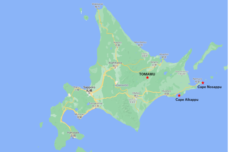
しかしこのコロナ禍。いつも通りとはいかない。そこで、日本の47都道府県中、人口密度ランキング47位の北海道。つまりこの最も人口密度の低い場所で、さらなる圧倒的ソーシャルディスタンスを確保できる場所へ向かうことにした。目的地はまだ訪れたことのなかった北海道の最東端、納沙布岬。道東に残されたサンクチュアリを訪れる。
But this corona disaster. It’s not going to be business as usual. So I decided to go to Hokkaido, the 47th most densely populated prefecture in Japan. In other words, we decided to go to a place with the lowest population density where I could secure an even more overwhelming social distancing. My destination was Cape Nosappu, the easternmost point of Hokkaido, which I had never visited before. I will visit the remaining sanctuary in the east of Hokkaido.
これはその時の記録です。でも、本来のこのエリアのベストシーズンは6~8月と言われ、まさにこれから。これからの季節に訪れるのにももってこい。そこでここに紹介させていただきます。
This is a record of that time. But the original best season for this area is said to be June to August, which is just around the corner. It’s a great place to visit in the coming season. So I will introduce it here.
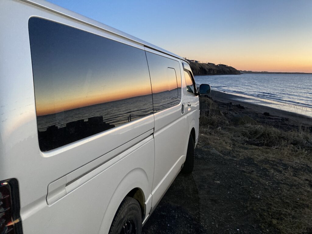
コロナだから。というのもあるが、北海道は圧倒的に車での観光をお勧めする。公共交通機関では行けないような場所だらけだし、そういうところの方が観光地化されておらず本当の北海道の表情を見ることができる。そしてさらに僕の車は後ろがベッドになっている車中泊仕様。だから人に会うことがあるのは食事の時か温泉でお風呂に入るときくらい。ありがたいことに最近では車の燃料はどこでも誰とも接せずにセルフで入れられる。
Although it may be because of the corona pandemic, I would definitely recommend sightseeing in Hokkaido by car. There are a lot of places you can’t go by public transportation, and you can see the true face of Hokkaido in those places that are less touristy. In addition, my car has a “bed” in the back, so I can stay in the car overnight. So the only time I see people is when I’m having a meal or taking a bath in an onsen. Thankfully, these days, you can fill up your car by yourself without any contact with anyone.
さて毎年恒例、僕のスノーシーズンを締めくくるクロージングトリップの始まりです。
まずベースであるトマムから4月3日に釧路へ移動。
Here we are at the beginning of my annual closing trip of the snow season.
First, I moved from my base in Tomamu to Kushiro on April 3.
4日は生憎の雨。
それでも弟子屈町の硫黄山へGo。
On the 4th, it was raining.
Still, I went to Mt.Ioh in the town of Teshikaga.
そして釧路から約1時間半。
いつぶりだろう?久しぶりの硫黄山。アイヌ語で「アトサヌプリ」、裸の山という意味。
And about an hour and a half from Kushiro.
How long has it been? It’s been a while since I’ve been to Mt. Ioh the Ainu language, it means “Atosanupuri,” meaning “naked mountain.
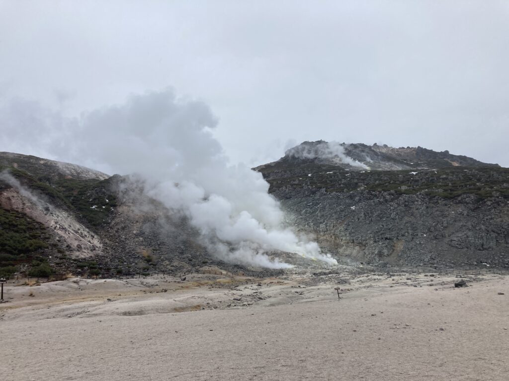
吹き出した硫黄からもくもくと湯気が立ち上り、あたりは大変迫力のある景色です!
a lot of steam coming from the sulfur spewed from the mountain, the scenery is very impressive!
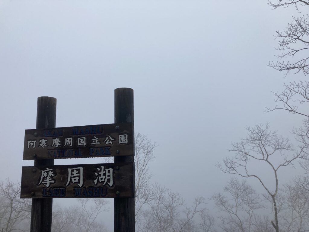
そこからほど近いお店でしぼりたての牛乳を使用した手作りアイスクリームの専門店「くりーむ童話」でアイスを食べて今度は摩周湖へ。アイヌ語で「カムイトー」、神の湖。
Not far from there is a store that specializes in homemade ice cream made from milk fresh from the cow, “Cream Dowa”. After eating an ice cream, I headed to Lake Mashu which is the Ainu word for “Kamuito,” the lake of the gods.”
霧に包まれていることが多く、”霧の摩周湖”として知られている
こんな日は間違いなく・・
Lake Mashu is often shrouded in fog, and is known as “Foggy Mashu”.
On a day like this, there’s no doubt…
ですよねー。w
真っ白!!!w
I know, right? lol
It’s all white! lol
前回は雲ひとつない快晴で見られたのだが、この場所はこっちの方が摩周湖らしいのかも??
The last time I saw this place, it was clear and cloudless but maybe this is more like Lake Mashu?
そして、釧路に戻り釧路市内をふらり。もちろん移動中は近くのサーフポイントもしっかりとチェック。
Then I returned to Kushiro and wandered around Kushiro City. Of course, while I was on the move, I made sure to check out the nearby surf spots.
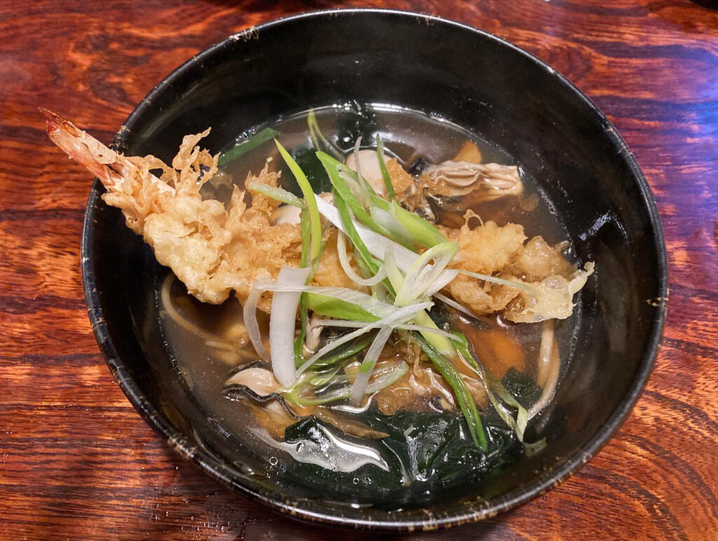
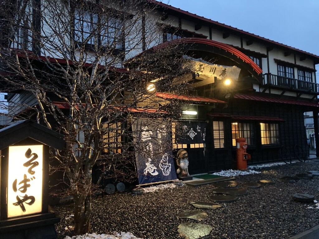
さらにお隣の街へ移動して、厚岸産のカキがぶち込まれた美味な「カキ天そば」なるものを流し込む。
牡蠣の天ぷらかと思いきや、牡蠣とエビの天ぷらであったことは予想外ではあったが、味は間違いなし!!店構えもいい感じだ。
I moved on to the next town, where I washed down some delicious “oyster tempura soba” with oysters from Akkeshi.
I didn’t expect it to be oyster tempura, but instead it was oyster and shrimp tempura, but it definitely tasted good! The store’s appearance is also very nice.
すべて満たされたところで、この日は終了。
Once everything was filled, the day was over.
5日、朝から東へ
もう4月だというのに、夜の間に雪が降ったようで辺りはうっすら雪化粧。
昨日食べた牡蠣が育った厚岸湾を眺めながら、釧路から東へ約55km、愛冠岬へ。
5th, heading east in the morning.
It was already April, but it seemed to have snowed during the night, and the area was covered with a light dusting of snow.
I headed for Cape Akkeshi, about 55 km east of Kushiro, looking out over the bay where the oysters I ate yesterday were grown.
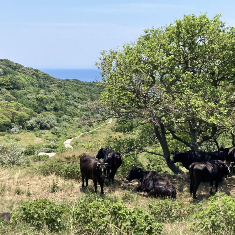
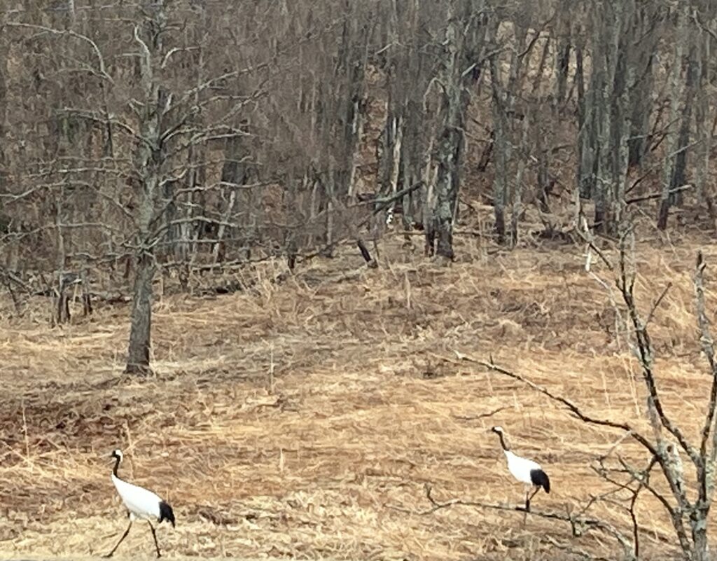
こんな時間にこんな場所、だーれもいないだろう…、と思っていたら、あ、鹿だ!
そんな時間は彼らにとっての楽園。最初は森の中にその姿を見つけ、そーっと観察しながら歩いたんですが、あちらこちらに、いることいること…、というか、いすぎ!!w
I thought, “Who would be here at this time of the day,” but then I saw the deer!
Such a time is paradise for them. At first, I spotted them in the forest and walked around, observing them gently, but they were everywhere. I mean, too many! lol
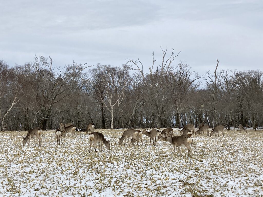
数で負けないって思ったんでしょうね。全く逃げない。そーっと歩く必要なんてありませんでした。w
I guess they thought they were outnumbered. They didn’t run away at all. There was no need to walk softly lol
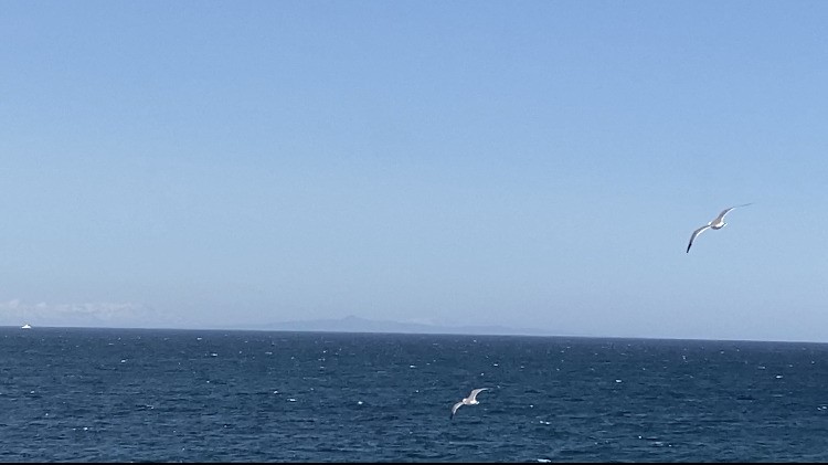
一人だったので相手の多さにちょっと怖いくらいでしたが、彼らの朝食を食む音や息づかいまで聞こえて「これぞ北海道!」な素敵な時間。おはよう!って優しく声をかけます。アカゲラ(キツツキ)もかなり近くで見ることが出来ました。そしてもちろん景色も良し。
I was alone, so I was a little scared by the number of deer, but I could hear them eating their breakfast and breathing, which made me think, “This is Hokkaido!” It was a wonderful time. Good morning! I said to them gently. I was also able to see a great spotted woodpecker very closely. And of course, the scenery was great.
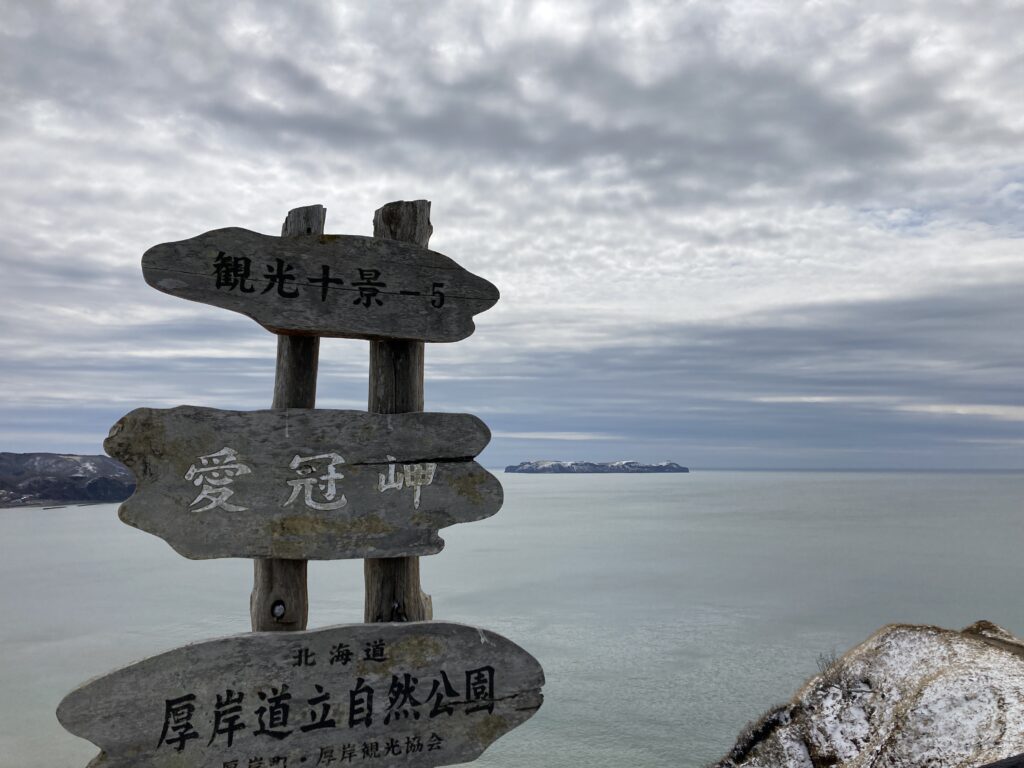
愛冠(あいかっぷ)岬の原名はアイヌ語で「アイ・カップ」、矢の上のモノという意味で、そこには「矢が届かない」というところから「できない」や「届かない」という意味があるんだそう。目の前には海鳥繁殖地として有名な大黒島・小島も。
The original name of Cape Aikappu is “Ai-kappu” in the Ainu language, which means “thing on an arrow,” and it has the meaning of “can’t” or “can’t reach” from there. In front of me, there are Daikoku island and Kojima island, famous as seabird breeding grounds.

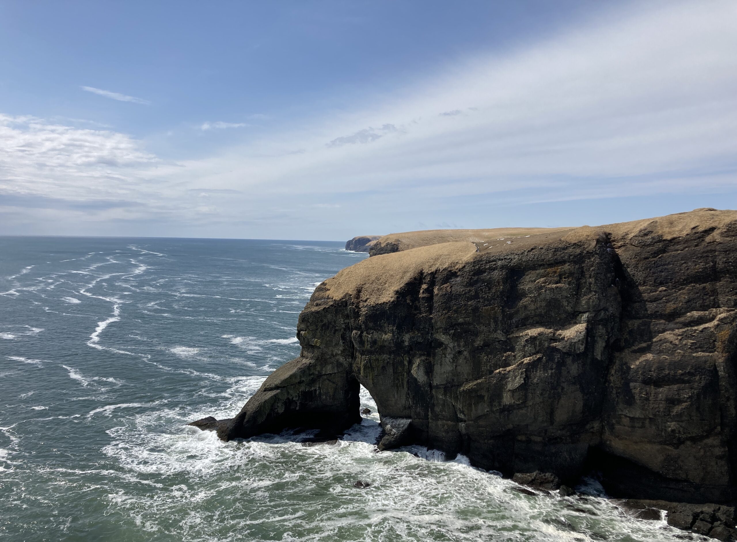
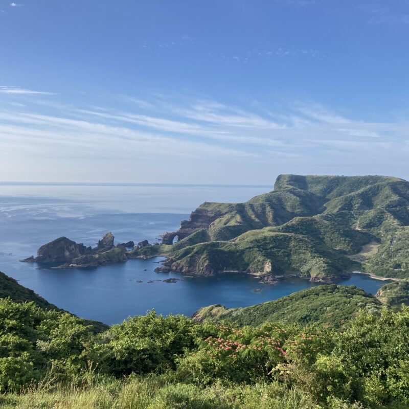
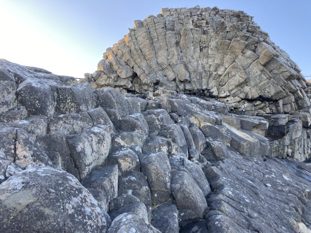
そこから東へ約30km、涙岬と立岩にも立ち寄る。岬の岸壁から少し離れて、独立して海面から突き出ているのが立岩。そして岬の下に穴があいているのが涙岬。この涙岬には悲しい言い伝えがあるらしいのですが、今ではただただ力強い自然の彫刻。
About 30 km east of there, I stopped at Namida Cape and Tachiiwa. “Tachiiwa” is the one that sticks out from the surface of the sea a little farther from the shore of the cape. And at the bottom of the cape, there is a hole called “Namida Cape”. There is a sad legend about this Namida Cape, but now it is just a powerful natural sculpture.
さらに東へ約10km、琵琶瀬展望台からラムサール条約にも登録される霧多布湿原を望みます。
About 10 kilometers further east, from the Biwase Observatory, you can see the Kiri-Tappu Marsh, which is registered as a Ramsar site.
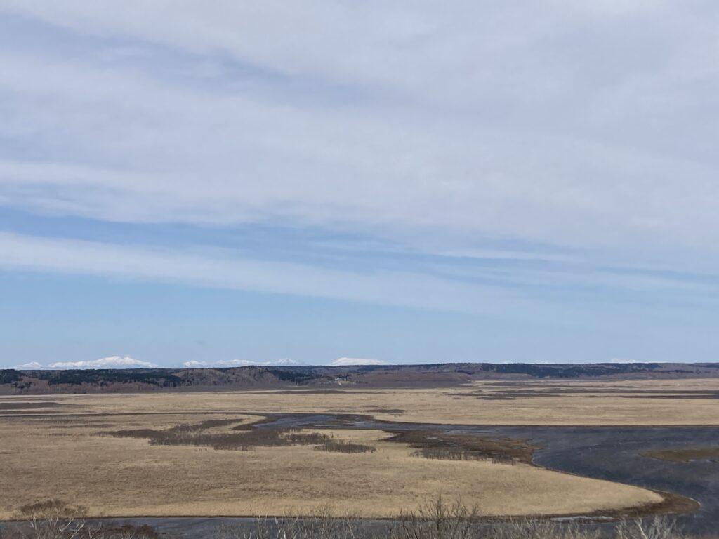
ラムサール条約の正式名称は「特に水鳥の生息地として国際的に重要な湿地に関する条約」なのですが、日本国内で登録されている52ケ所のうち実に13の湿地は北海道にあります。この湿地の奥に見える真っ白な峰々が見えるでしょうか?知床連山が近づいてきました。
The official name of the Ramsar Convention is the “Convention on Wetlands of International Importance, especially as Waterfowl Habitat,” and 13 of the 52 registered wetlands in Japan are in Hokkaido. Can you see the pure white peaks at the back of this wetland? The Shiretoko mountain range is getting closer.
そして振り返れば太平洋。この広大な湿地から海へと養分がたっぷり注ぎ込まれるため、海産物にも恵まれています。まさに「森は海の恋人」
And if you look back, you will see the Pacific Ocean. This vast marshland pours plenty of nutrients into the sea, so it is blessed with marine products. “The forest is truly a lover of the sea.”
あぁ、この何もない感じ。最高だ。
日本はどこに行っても人工物ばかり。
でも道東には本当の “何もない” がある。
日本に残された数少ない本当のラストフロンティア。
Oh, this feeling of nothingness. I love it.
Everywhere you go in Japan, there is always something artificial.
But there is a real “nothingness” in the east of Hokkaido.
It is one of the few true last frontiers left in Japan.
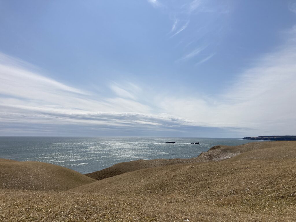
琵琶瀬湾を見ながら、さらに東へ約10km、霧多布岬へ。
While looking at Biwase Bay, head further east for about 10 km to Cape Kiritappu.
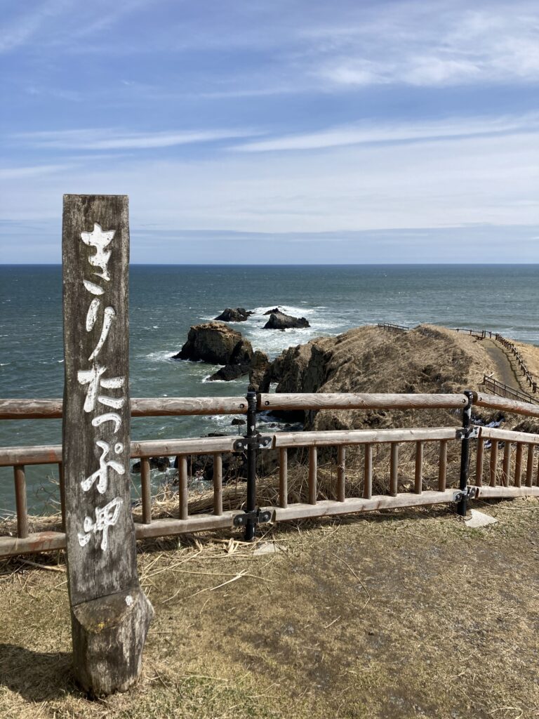
ちなみにあまり知られていませんが正式名称は「湯沸岬(とうふつみさき)」。
霧多布というのは通称で、霧多布というのはアイヌ語の「キタプ(茅を刈る所)」から来ている言葉だそうです。
By the way, although it is not well known, the official name is “Cape Tofutsu”.
The name “Cape Kiritappu” is a common name, and the word “kiritappu” comes from the Ainu word “kitapu” (a place to cut the thatch).
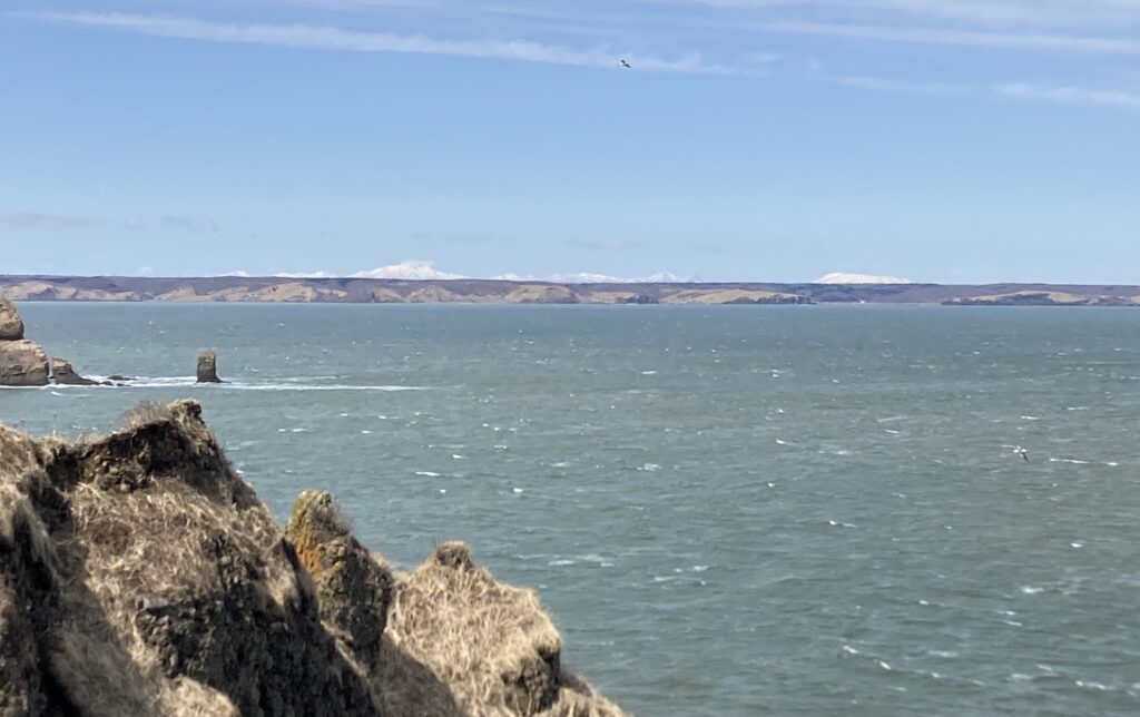
ここからも根室半島のさらに奥の知床半島に鎮座する、知床連山の白い頂が見える。美しい。。。
From here you can also see the white peaks of the Shiretoko mountain range, which sits on the Shiretoko peninsula further inland from the Nemuro peninsula. Beautiful!
そこから太平洋沿いに東へ約90km。
From there, it is about 90 km east along the Pacific Ocean.
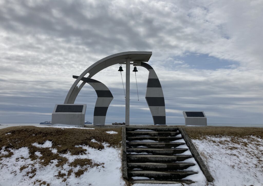
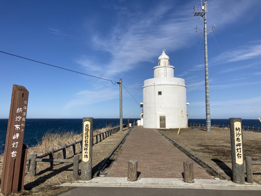
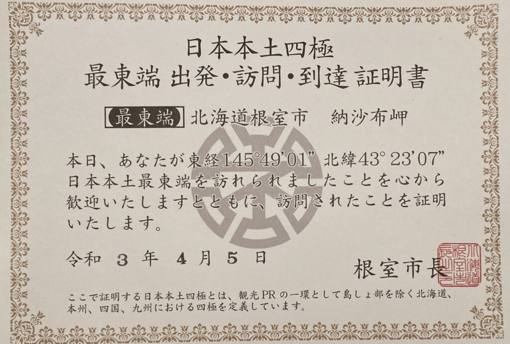
ようやく今回の目的地、北海道の最東端「納沙布岬」に到着!!本土最東端の岬で、その名前はアイヌ語の「ノッ・サム(岬の傍ら)」に由来しています。
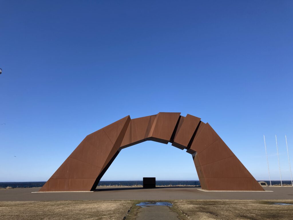
ここからは、北方領土の国後島が目の前で、近くの広場には巨大なモニュメントもあります。風も強く、あまりにも寒かったので、入館無料だった近くの北方領土資料館に逃げ込みました。
Finally, we arrived at our destination, the easternmost point of Hokkaido, Cape Nosappu! This is the easternmost cape on the mainland, and its name comes from the Ainu word “Nok Sam”(meaning “by the cape”) .
From here, Kunashiri Island, the Northern Territories, is right in front of us, and there is a huge monument in the square nearby. It was very windy and too cold, so I escaped to the nearby Northern Territories Museum, which was free to enter.
さて、東の果てまで来たら今度は太平洋側ではない根室湾側に沿って西へ走ります。
Now that we’ve reached the far east, we’ll drive west along the Nemuro Bay side, which is not on the Pacific Ocean side.
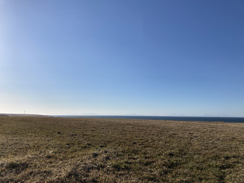
なーんもない。。。
南を見ても、北を見ても
知床半島の知床連山だけがはっきりと見えます。
There’s nothing.
Look to the south, look to the north.
Only the Shiretoko mountain range of the Shiretoko Peninsula is clearly visible.
なんて美しいんだ。。。
写真じゃ伝わらんなー
Photos can’t convey the beauty.
What a beauty.
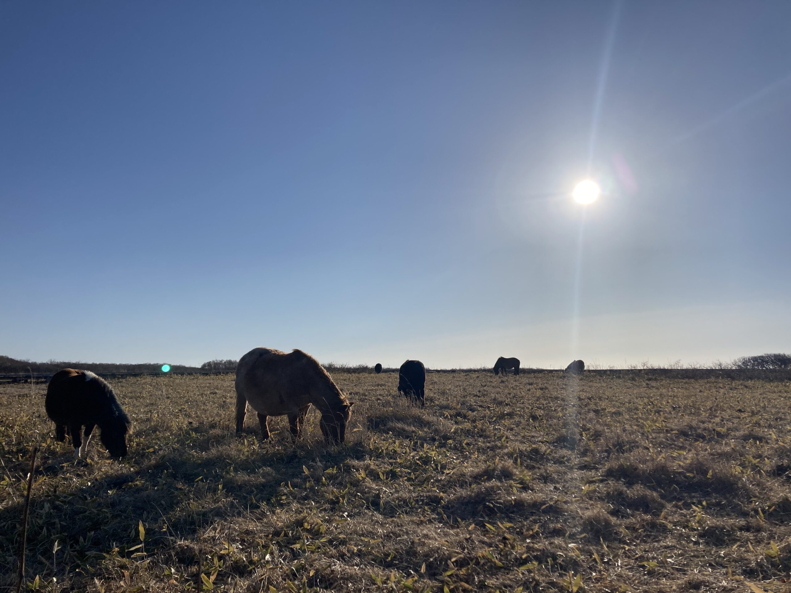
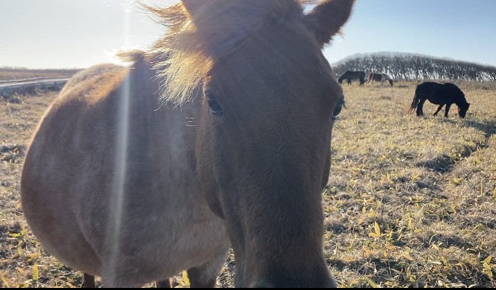
そして納沙布岬から約10kmのところ、北方原生花園なるものが。おそらくもう少し温かくなってくれば花畑になるのでしょう。柵があるだけで誰でも無料で入れるのですが、そこにポニーが放し飼い。
And about 10km from Cape Nosappu, there is the Northern Primeval Flower Garden. It will probably become a flower garden when it gets a little warmer. There is only a fence, so anyone can enter for free. There are ponies roaming free.
傾いた太陽の柔らかい光、風の音、ポニーが草を食む音。それだけ…。そこには別の時間が流れているよう。でもこれが本当の時間。ポニーにも全然さわれちゃう感じで、近づいてきてくれた子はヨシヨシしました。
The soft light of the slanting sun, the sound of the wind, the sound of ponies munching on grass. That’s it… It’s as if another time is flowing there. But this is the real time. I was able to touch the ponies, and I patted the ones that came close to me.
あぁ、最高…、って、でも流石に日も傾いてきて風も強くってかなり寒い。もっといたかったけど寒さに負けて車に戻ります。そうこうしてるとだんだん陽が低くなる。
It’s so nice… But the sun was setting and the wind was blowing hard, so it was pretty cold. I wanted to stay longer, but I gave in to the cold and went back to the car. Then the sun was getting lower and lower.
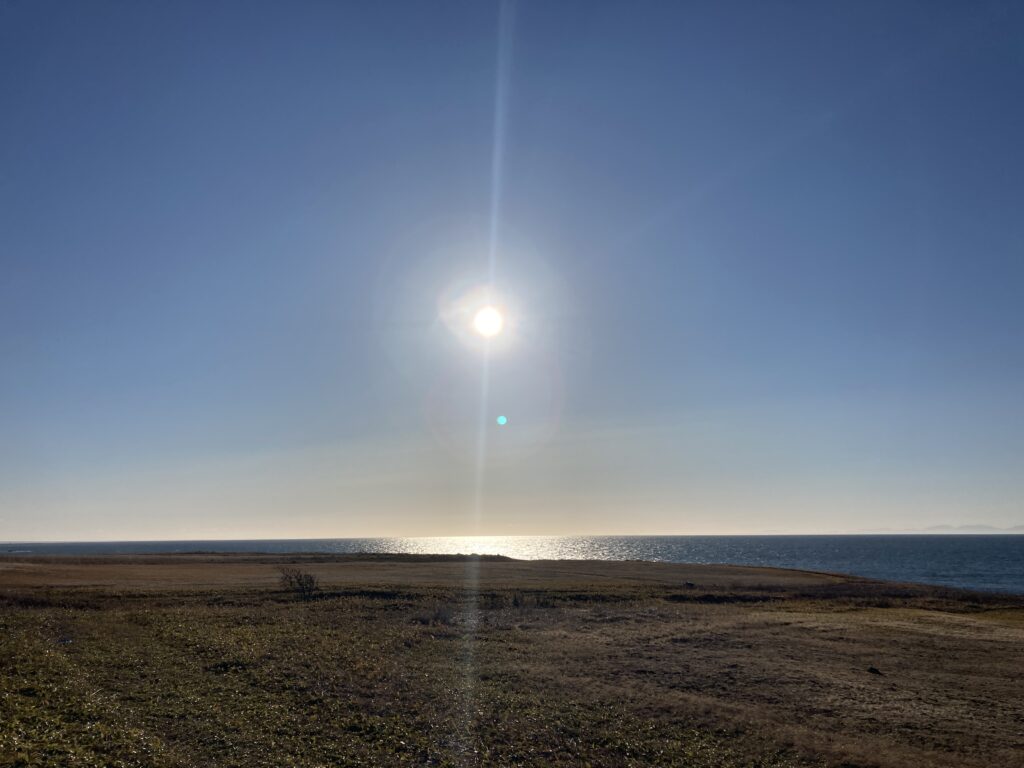
きっとここからだと、太陽が水平線から上り水平線に沈んでいくところを、邪魔するものが何ひとつない状況で、完璧に全て見ることができるんですね…。
もう少し暖かい時に一日中この地に寝そべって、たまに海入って、ただただ過ごしてみたいな。いつか。
I’m sure that from here, I can see everything perfectly, with nothing in the way, as the sun rises from the horizon and sets into the horizon….
I’d like to lie here all day when it’s a bit warmer, take a dip in the ocean once in a while, and just spend time. Someday.
んでそこから西へ約15km
根室市に。今夜はこのあたりに泊まろうと、と思ってたのですが、まだ時間があったので、太平洋側で見過ごした天然記念物の根室車石のある花咲岬まで約6.5kmほど南下。信号もほとんどない道東。あっという間です。
Then, about 15km west of there.
Nemuro City. I was planning to stay here tonight, but there was still time, so I went south about 6.5km to Cape Hanasaki, where there was a natural monument, Nemuro Kurumaishi, which I had missed on the Pacific side. There are almost no traffic lights in East Hokkaido. It goes by so fast.
根室市に戻って少し早めの夕食を取ることに。
なんせ、道中にはあまりお店もないものですから、朝から山岳用の行動食をちょこちょこつまむ程度でしか食べてない。腹ペコです。
Back in Nemuro City, I decided to have an early dinner.
There weren’t many stores along the way, so I had only eaten a little bit of mountain food since morning. I was starving.
根室が初めての僕は、ベタに根室グルメのエスカロップをチョイス!略してエスカとも呼ばれるエスカロップはバターライスにポークカツを乗せてドミグラスソースを掛けた北海道根室市のご当地料理。おー。これが!
As it was my first time in Nemuro, I chose the Nemuro gourmet dish, Escalope! Escalope, also known as esca for short, is a local dish of Nemuro City, Hokkaido, consisting of buttered rice topped with pork cutlet and doused with demi-glace sauce. Oh. This is it!
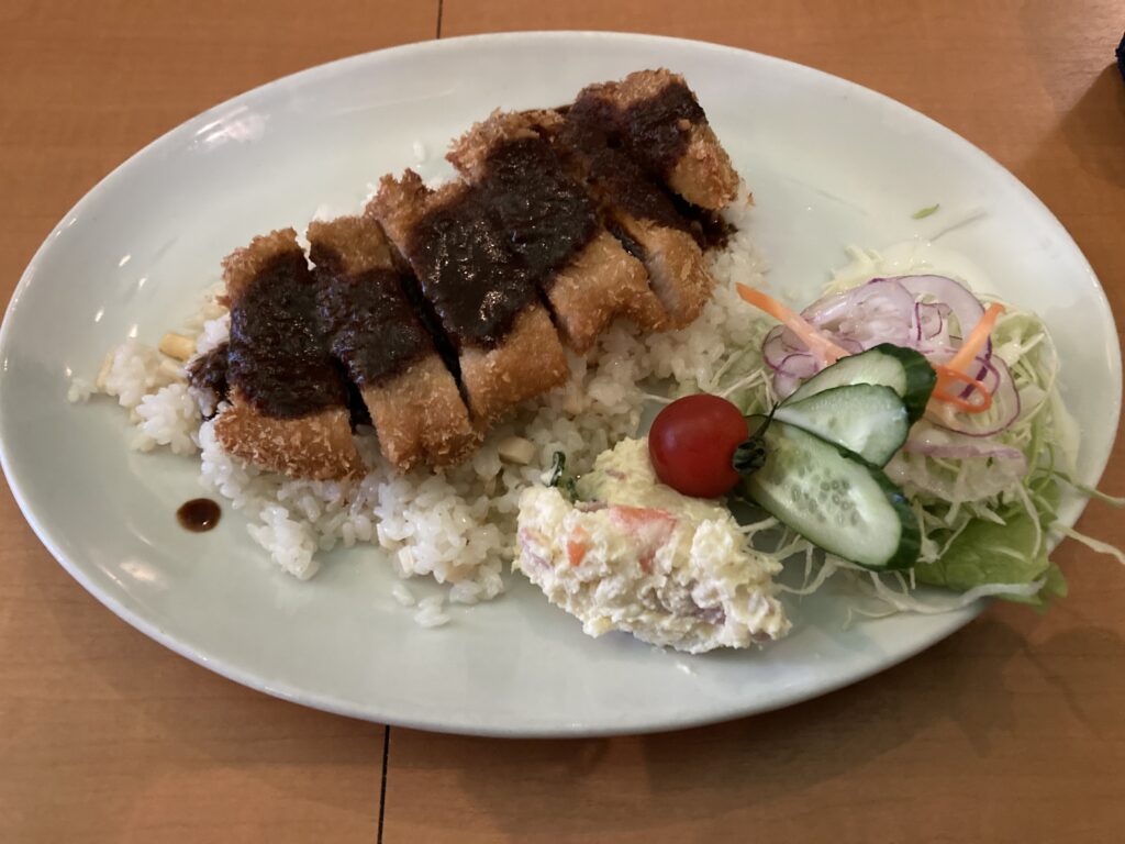
想像以上にバターライスのバターが滴るくらいに多くってパンチありでしたが、でも確かにバッチリうまかった!!
It was more impactful than I imagined, with more butter dripping from the butter rice, but it sure was perfectly good!
んで、ちょっと周辺もうろうろして、美しすぎる知床連山を染める夕焼けを眺め、僕の旅のパートナーである車も夕陽に染まり、
Then, I walked around the area for a while, and watched the beautiful sunset over the Shiretoko mountain range, and my travel partner, the car, was also dyed by the sunset.
夜の帳が下りるとともに、就寝。
As the night falls, I go to bed.
景色を最大限楽しむために暗くなったら行動しないというのが僕の旅のルール。
それにしても僕たちが生きているこの地球はとんでもなく美しい!!
My travel rule is not to take any action after dark in order to enjoy the scenery to the fullest.
And yet, this planet we live on is unbelievably beautiful!

中島 力
Riki Nakajima
Blog:https://ameblo.jp/rikistyle/
Instagram:https://www.instagram.com/rikinakajima/
Guide Company HP for Winter :https://rikijg.com/jp/
Guide Company HP for Green Season :https://www.rikijapowguide.com
1981年、滋賀県出身。 カナダ・ウィスラーに留学中、CSIAインストラクター資格と、日本人初となるCFSAフリースキーインストラクター資格を取得。帰国後は数々のフリースキー大会への参加に加えて、バックカントリーでの滑走へも活動の場を広げた。ここ数年は、北海道トマムスキー場をベースに、スキーのレッスンやガイド、イベント運営、MCなどその動きは多岐にわたっている。また、毎年春になると海外へとわたり、アドベンチャー要素の高い山行を継続的にトライし、その模様を映像や写真、イベントで表現している。 ガイドカンパニー「RIKI JAPOW GUIDE」代表。
Born in Shiga Prefecture in 1981. While studying in Whistler, Canada, he became a certified CSIA instructor and the first Japanese freeski instructor to receive the CFSA freeski instructor certification. After returning to Japan, he expanded his activities to include backcountry skiing in addition to participating in numerous freeskiing competitions. For the past few years, he has been working at Tomamu Ski Resort in Hokkaido, giving ski lessons, guiding, managing events, and acting as an MC. He also travels abroad every spring to try his hand at high adventure mountain climbing, and expresses his experiences through videos, photos, and events. He is the representative of the guide company “RIKI JAPOW GUIDE”.
#絶景 #アイランドホッピング #ダイビング #Diving #Amami #special #特別編 #堀江武史 #竹谷隆之 #ニクネカムイ #アートトイ #コレクタブルトイ #シンゴジラ #3Dプリント #薬師如来 #YAOYOROZ #TakeshiHorie #TakayukiTakeya #Nikunekamui #arttoy #collectabletoy #ShinGodzilla #3Dprinter #JapaneseCulture #海外旅行 #国内旅行 #Trip #大湯環状列石 #OyuStoneCircles #上高地 #Kamikochi #山岳リゾート #Mountains #Resort #リゾート #リゾートホテル #luxuaryhotel #Karasawa Cirque #長崎県 #Nagasaki
ZEKKEI×SOFT | Onioshidashien
Jomon Journey of nawa to yajiri
Artist Interview No.6 ‒Yusuke Bonsai Kid - Part 1